A collaborative project between Universiti Brunei Darussalam, Korea University (Republic of Korea) and National Institute of Forest Science (Republic of Korea) entitled “Monitoring and quantification of spatial-temporal changes in carbon stocks according to forest types of Brunei Darussalam” is currently in progress. It focuses on establishing forest inventory and baseline data on a national scale for Measuring, Reporting and Verification (MRV) framework, in order to contribute to Brunei Darusaalam’s national greenhouse gas inventory report for UNFCC, and to assess Brunei Darussalam’s readiness to participate in Reducing Emissions from Deforestation and Degradation (REDD+) mechanisms. This project is the second ongoing iCUBE research collaboration with Korea University. This research project is fully funded by research grants from the Korea Forest Service where a total of BND 50,000.00 is awarded directly to the UBD researchers, through the Principal Investigators, Dr Rahayu Sukmaria Hj Sukri and Dr Faizah Hj Metali.
In the period of 2018-2019, the main components of the research involved estimating forest Carbon through i) field survey; ii) remote sensing.
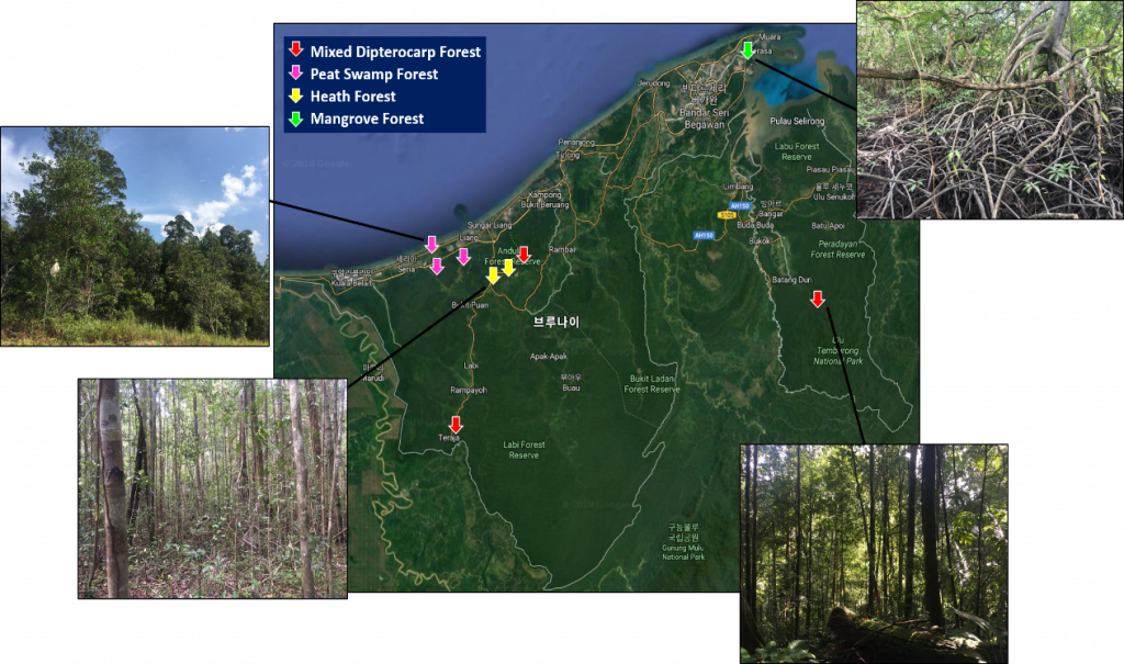
In Brunei Darussalam, forests are located in 80.6% of the entire land cover. In this project, nine 20m x 20m permanent plots in a total of nine selected locations of forests (mainly consist of three mixed Dipterocarp forest (MDF), three peat swamp forest (PSF), two heath forest (HF) and one mangrove forest (MF)) are designated for the field survey method where the diameter of trees (larger than 10 cm in diameter) in the plots are measured. Voucher specimens are collected for taxonomic ID.
As of October 2019, seven 20m x 20m plots in seven locations (three PSF, two MDF and two HF) were set up and data of tree diamaters and species identitication were recorded in some of the locations.
Preliminary results have shown that the most number of trees (n=275) were identified at the Peat Swamp forest in Lumut with the average DBH (diameter-at-breast-height) of 25.64 cm.
In terms of trees species richness and diversity, a total of 85 species and 32 species was recorded in all nine plots in Heath forest at Bukit Sawat and Peat swamp forest at Badas respectively.
Figure 1. Locations of permanent plots in MDF, PSF, MF and HF
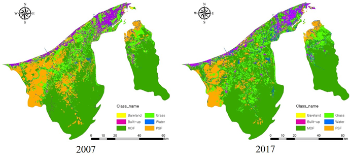
Meanwhile remote sensing has been used to identify forest cover in Brunei Darussalam. Using an Image-segmentation method after the pretreatments of image, MDF, grassland, PSF, city, watershed, and bare land were classified
Figure 2. Land cover of Brunei Darussalam in 2007 and 2017
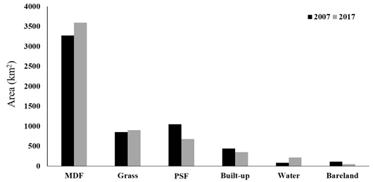
The area of MDF and PSF was 3,270km2 and 1,048 km2, respectively, and governed 74% of land cover in Brunei Darussalam (Figure 5). The proportion of land cover is 19% higher than the land cover survey in 1984. The difference might be caused by land area categorized as a secondary forest in 1984. Using the remote sensing methods only, secondary forest cannot be identified.
Figure 3. Land area of Brunei Darussalam in 2007 and 2017
Report (and photos) by: Yujin Roh, Hazimah Hj Mohd Din & Wardah Hj Tuah